Wodehouse from Generaalskop.jpg#joomlaImage://local-images/hikes/wodehouse-from-generaalskop
Ribboks Peak
Ribboks Peak
Ribbok Hut
Ribbok Hut
Rhebok / Ribbok Hiking Trail
Ribbok Hut
Ribbok Hut

About Rhebok / Ribbok Hiking Trail

The Ribbok Trail is the flagship trail in Golden Gate. The route, which covers a horizontal distance of 28 km and a vertical height of 600 m (nearly 1 km if you leave the path and head up Ribbokskop; the highest point in the Free State), should take two days of easy walking. There is a overnight house – Ribbok Hut – with Running water, sleeping quarters and a fire place near the halfway mark.

The first half of the walk is a gentle, mostly flat walk on the northern side of the main road. This pleasant wander takes you along sandstone gullies that form breathtaking rock pools during the wet season (October-March). After passing the Wilgenhof Environmental Education Centre and possible the most picturesque soccer field in the province, the route crosses the main road at the western gate where it gradually rises until Ribbok Hut.

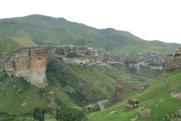
The second half of the trail is much harder than the first due to the increased incline of the path. The fantastic views more than make up for the increased difficulty though. One can look down into the Caledon River (Mohokare River in seSotho) that forms the border between South Africa and Lesotho from the high points of the route. There is extended plateau at the foot of final last slopes up Generaalskop (2 732 m) that often has grazing Burchell’s Zebra, Black Wildebeest, and Red Hartebeest. Mountain Reedbuck and Chacma Baboon can be seen on the downward path from the plateau back to the Glen Reenen Rest Camp.

If you feel energetic, then it is a good idea to try and summit Generaalskop from the plateau while on this route. It is a moderate-to-difficult climb where the greatest challenge is choosing the best route to the top (there are no marked paths) – it is probably best to leave your backpack at the plateau to make the final climb easier.

Ribbokskop (2 829 m) is a single peak with steep sandstone cliffs. You will have to make a large detour to summit this peak and you should be willing to tackle some difficult climbs (although ropes are not essential). I advise against attempting this peak with you heavy backpacks because you’ll need to get as close to the rock face as possible to maintain your balance.

The Ribbok Route, Generaalskop and Ribbokskop can also be finished separately in 8-11 hours each if you are carrying a light pack and are willing to march at a vigorous pace.

Rhebok / Ribbok Hiking Trail
Ribbok Hut
Ribbok Hut

Hike Directions

The two-day trail, which involves trekking up to the highest point in the park (Generaalskop), gives one a wonderful way to see the park, including some of the best views out over Mont-aux-Sources and the Malutis.

DAY ONE

Day one is 14 km to the overnight Rhebok Hut – get an early start as, especially in summer, the days can be very hot and afternoons invariably produce an electric storm. The trail starts with a climb up Brandwag and past some of the best sandstone cliff formations in the province. The trail evens out past rock pools perfect for swimming (do not tarry too long) and through grasslands, when it descends to the overnight hut.

DAY TWO

Day two is 14 km and is a difficult walk, taking up to 8 hours to complete. The start includes heading up a waterfall to where the trail heads up generaalskop with some steep sections (not great to do in the heat of the day but pack clothing for any eventuality, as weather in the mountains is unpredictable). After the ascent, there is the descent (very steep in places) before venturing down a rather picturesque kloof and down to glen Reenen (hot showers all round).

About the area

Golden Gate Highlands National Park is secretly tucked away in the rolling foothills of the Maluti Mountains and surrounded by breathtaking scenery of wildlife and lush vegetation.

The Golden Gate National Park is a Free State Nature Reserve in South Africa, located in the north eastern part of Free State and derives its name from the brilliant shades of gold cast by the sun on the sandstone cliffs, especially the imposing Brandwag rock. The area is famous for its captivating scenery, invigorating climate and the accommodation offered in hotel rooms, rondavels (round huts) and self-catering chalets.

Address & Contact details

Golden Gate Highlands National Park, Free State

Email: This email address is being protected from spambots. You need JavaScript enabled to view it.

Track Map

GPS Track Details
Track length: 27.56 km
Total ascent: 1196 m
Total descent: 1197 m
Difficulty Level: 4/5 - Hard

Location Map